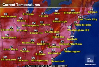
 The region is baking once again as the sweltering heat wave of 2006 rolls on. Check out temperatures across the East Center United States (see image at right). Air temperatures in most locations have soared into the upper 90s...and the harsh thing is--those aren't even the heat index temperatures. Factoring in the humidity in the air (currently running at around 35-45%), it feels like it's well over 100 degrees in many locations.
Washington, DC may possibly break its record for highest temperature today--100 degrees--but the thermometer needs to jump up two more degrees very quickly, before the sun begins its decent. At 4PM, the temperature at Reagan National weather a stifling 99 degrees with a heat index of 106.
Elsewhere around the region, the records for both Dulles and BWI will likely remain intact. The high temperature at BWI looks like it will top out around 98 degrees, and Dulles should top out around 97 degrees.
Relief is coming...
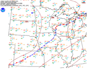
A cold front currently draped across the Upper Midwest is slowly making its way eastward. There is a noticeable drop in temperature behind the front, with many locations reporting temps in the upper 70s and mid 80s. This front will close in on the region tomorrow afternoon, and should traverse the region on Friday, dropping the temperatures a good 10 to 15 degrees for the weekend--a welcome bit of relief from the heat!

Surface Analysis courtesy of the HPC
However, with the prospect of more comfortable weather comes the threat of severe storms. There is a slight risk that a few severe storms bubble up during the afternoon, mainly northwest of the region. A little better shot for more organized thunderstorm activity moves in on Friday.
 Tropical Troubles...
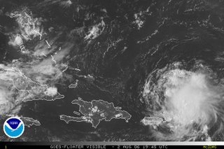
Tropical Storm Chris continues to churn just north of the Leeward Islands with 65 mph winds and a central pressure near 1007 mb--quite high for a storm of his strength. Chris looks disorganized on visible satellite images (see right) with convection being sprayed to the east by 10 - 20 kt easterly wind shear. Nonetheless, Chris is expected to intensify into the first hurricane of the season, and may pose a threat to the western Gulf Coast in the near future.
Image courtesy of the National Hurricane Center


