EXCESSIVE HEAT WATCH EFFECTIVE FROM TUESDAY AFTERNOON THROUGH THURSDAY AFTERNOON. Heat index values will likely exceed 110 degrees in many locations.Sultry Weather not going anywhere soon: After a brief respi
 te from the intense DC summertime weather last week, the hazy, hot, and humid weather known all to well to Washingtonians has returned once again. Temperatures over the past three days have once again soared into the mid 90s. By most standards, high temperatures in the 90s would be bearable, but adding in a touch of tropical air makes it feel incredibly sticky and uncomfortable, and more of it's on the way.
The bubble of extraordinary heat that had been plaguing the desert Southwest for over two weeks finally receded yesterday as a trough slid in from the west. Now it's our turn to feel the heat as a dome of anomalously high heights in the middle and upper atmosphere slides eastward, and proceeds to bake the Eastern half of the country. All indications point towards a ramp-up in temperatures through the next four to five days. Temperatures by Tuesday will likely hit the triple-digits, and this combined with dewpoints approaching 80 degrees may produce heat indices eclipsing 110 degrees!
This portion of the National Weather Service Special Weather Statement outlines the potential hazards of heat this extreme:
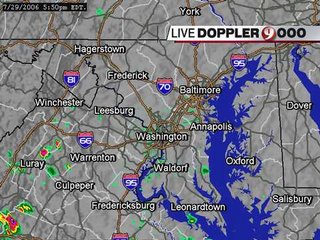
THIS BUILD UP OF HEAT COULD MAKE HEAT-RELATED ILLNESSES A SERIOUS THREAT...ESPECIALLY FOR OLDER GROUPS...PEOPLE WITH ILLNESSES...AND PEOPLE LIVING IN NON-AIR CONDITIONED HOMES. NOW IS A GOOD TIME TO BEGIN PREPARING FOR A HEAT WAVE ACROSS THE REGION THROUGH MIDWEEK.With the heat comes the potential for thunderstorms on a daily basis (called diurnal thunderstorms due to their predilections to bubble up during the heating of the afternoon, and die out after sunset). Tiny, isolated thunderstorms are popping up across the region, moving in a slow southeastward track towards Central Virginia (See image top right, courtesy of WUSA 9 News Weather). These storms will persist for a few more hours before dissipating after sunset.
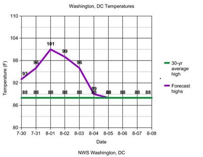
 Temperatures should moderate by the end of next week, but will remain in the mid to upper 80s before a trough approaches the region in 7-8 days. And there's some more good news: The average high temperature in DC peaked last week at 89 degrees, and will continue to fall as we get closer to Autumn. The NWS forecast high temperatures are plotted above (purple) for the next seven days. Notice the "cool down" by the end of next week as we return to near-normal temperatures.
Are Hurricanes Really increasing in Intensity?
I have long been skepticic of the whole "global warming is making the hurricanes stronger" theory. Granted, I believe in anthropogenic warming, but don't think it has happened on a scale large enough to effect hurricane intensity like many have suggested (at least not yet). A recensnippetit in the Washington Post outlined the fact that manscientiststs hold as fact: that hurricane intensity was underestimated for a long period of time while satellites were being developed.
Very few satellites were floating around in space during the 1960s and 70s, and those that were sampling data were doing so at very low resolutions. A satellite would have to view a hurricane at an angle, and this combined with the low horizontal resolutions, lead to misinterpretationon and misrepresentation of hurricane intensity. Now, with the so-called hi-res satellites, and the development of an technique to objectively analyze hurricane intensity (Dvorak Technique), hurricane intensity measurements have gotten better, which, I think, has a lot to do with the stark increase in the number of intense hurricanes we're seeing worldwide.
 Image courtesy of the Georgia Institute of Technology
It is a proven fact that the number of hurricanes has remained relatively constant around the globe over the past 30 to 40 years, even though the number of intense hurricanes (Category 3 or higher) has nearly doubled. In my opinion, it is much easier to say "hey, that's a hurricane" on even the lowest resolution satellite images, than to distinguish between a 110 mph Category 2 Hurricane (not considered Intense/Major), and a 115 mph Intense, Category 3.


